Uncategorized

On March 12, 1997 the Morris County Freeholder Director Christopher Christie appointed Matthew Sprung to the Morris County Planning Board.  Matt made it his responsibility to learn all aspects of county planning.  In addition, he was always inquisitive, supportive and involved with staff initiatives and projects through out his tenure as a board member.  Matt Sprung was a great asset to the Morris County Planning Board and my great pleasure to have worked with him on a professional level.

Roman (Ray) Zabihach, Former Director of Planning Morris County Planning Board


NJDEP Proposes Amendment to the Monmouth County WQMP for 9 – Lot Residential Subdivision

Public Notice:


  TOWNSHIP OF MILLSTONE
ENVIRONMENTAL PROTECTION DIVISION OF COASTAL AND LAND USE PLANNING (NJDEP)  Proposed Amendment to the Monmouth County Water Quality Management Plan Public Notice Take notice that the New Jersey Department of Environmental Protection (Department) is seeking public comment on a proposed amendment to the Monmouth County Water Quality Management (WQM) Plan. This amendment proposal, entitled “Riverside Center”, submitted on behalf of XXXIII Associates/Riverside Center, LLC, would designate a 46.8 acre portion of Block 18, Lot 2.02 in Millstone Township, Monmouth County as a discharge to groundwater service area (SSA) of 19,999 gallons per day (gpd) to be served by on-site septic systems to serve a proposed 9 major lot subdivision. The subject property, located on the northern side of Route 33 about 1,000 feet east of the intersection with Jamesburg-Perrineville Road, totals 57.43 acres. 10.94 acres of the property are wetlands, wetlands buffers, and flood plain that will not be developed. Therefore, the proposed SSA would be 46.8 acres in order to accommodate the entire proposed development of 9 lots which would each range in size from 2.5 to 13.5 acres. This application has been reviewed in accordance with the Water Quality Management Planning rules that set the environmental standards to be applied to an amendment at N.J.A.C, 7:15-5.18, N.J.A.C. 7:15-5.24 and N.J.A.C, 7:15-5.25. Pursuant to P.L. 2011, c. 203, the Department, in consultation with the applicable wastewater management planning agency, may approve the inclusion of land within a SSA notwithstanding that existing treatment works may not currently have the assured capacity to treat wastewater from such land without infrastructure improvements or permit modification. Therefore, amendments to modify a SSA may be approved if such actions are compliant with the applicable sections of the Water Quality Management Planning rule (N.J.A.C. 7:15) regardless of whether capacity has been fully assessed, however, in accordance with N.J.A.C. 7:15-5.25(h)1, the projected wastewater flow of the project has been evaluated. The proposed wastewater flow, as calculated in accordance with N.J.A.C. 7:9A-7.4 is 19,999 gpd. The proposed project will be required to meet the 10 parts per million (ppm) nitrate dilution requirement for the New Jersey Pollutant Discharge Elimination System (NJPDES) permit that will allow for wastewater disposal via a new discharge to groundwater. A 19 acre portion of the neighboring Block 8, Lot 8.01 in Monroe Township, Middlesex County will be used for dilution purposes in order to meet the above referenced nitrate dilution requirement. Provisions of the above referenced NJPDES permit require the permitee to give written notification to the Department of any planned physical or operational alterations or additions to the permitted facility when the alteration is expected to result in a significant change in the permiltee’s discharge and/or residuals use or disposal practices; as well as notify the Department prior to any changes in ownership that require the transfer of the NJPDES permit. These requirements are specified in the NJPDES rules at N.J.A.C. 7:14A-4.2, and N.J.A.C. 7:14A- 6.7; and N.J.A.C. 7:14A-16.2, respectively. As outlined at N.J.A.C. 7:15-5.24, sewer service may only be provided to areas that are not identified as environmentally sensitive areas (ESAs), Coastal Fringe, Coastal Rural and Coastal Environmentally Sensitive Planning Areas, beaches, coastal high hazard areas, and dunes. Pursuant to N.J.A.C. 7:15-5.24, ESAs are defined as contiguous areas of 25 acres or larger consisting of habitat for threatened and endangered species as identified on the Landscape Project Maps of Habitat for Endangered, Threatened or Other Priority Species, Natural Heritage Priority Sites, Category One (C1) special water resource protection areas, and wetlands, alone or in combination. These areas are not included in the proposed SSA. In accordance with N.J.A.C. 7:15-5.24(b)1, to determine areas designated as threatened or endangered species habitat, the Department utilized the Division of Fish and Wildlife’s Landscape Project Maps of Habitat for Endangered, Threatened or Other Priority Species, version 3.1. Areas identified by the Landscape Project as being suitable habitat for threatened and endangered species Ranks 3 (State threatened), 4 (State endangered), and 5 (Federal endangered or threatened) are not to be included in proposed SSAs except as provided under N.J.A.C. 7:15-5.24(e) – (h), or unless a site has undergone a site specific Habitat Suitability Determination prepared in accordance with N.J.A.C. 7:15-5.26 that found the site to be not suitable habitat, or pursuant with N.J.A.C. 7:15-5.24(g)2, the Department determined the ESA is not critical to a population of endangered or threatened species the loss of which would decrease the likelihood of the survival or recovery of the identified species. Review of the project site has determined that no threatened or endangered species habitat exists on site. In accordance with N.J.A.C. 7:15-5.24(b)2, areas mapped as Natural Heritage Priority Sites are not to be included in proposed SSAs, except as provided under N.J.A.C. 7:15-5.24(e) – (h). Review of the project site has determined that no Natural Heritage Priority Sites exist on site. A Riparian zone has been identified on the property. Riparian zones or buffers are established along all surface waters, based on the surface water body’s classification designated at N.J.A.C. 7:9B, under the following regulations: the Flood Hazard Area Control Act Rules, the Stormwater Management rules, and the Water Quality Management Planning rules. The required buffer width for the Millstone River which is designated FW2-NT, is 50 feet. An April 26, 2006 Stream Encroachment Jurisdictional Flood Hazard Area Control Act letter from the Department’s Division of Land Use Regulation states that a stream encroachment permit is not required as no grading is proposed in the floodplain. In order to satisfy the Riparian Corridor Analysis, Millstone Township has adopted Ordinance No. 10-18 to satisfy the Riparian Corridor Analysis and to ensure the protection of the riparian corridors along all perennial and intermittent streams. As required, the adopted ordinance establishes and protects Water Resource/Buffer Conservation Zones (“stream corridor buffer”) adjacent to New Jersey Surface Water Quality Standards designated waters (excluding man-made) and regulates development within those zones. The stream corridor buffers vary in width depending upon the water body’s classification in the Surface Water Quality Standards at N.J.A.C. 7:9B-1.15. To become compliant, and in accordance with N.J.A.C. 7:15-5.25(h)5i, the Riparian Corridor Analysis has been satisfied by applying the 50 foot buffer to the applicable portions of the Millstone River, the adoption of Ordinance 10-18 and exclusion of the buffer area from the proposed SSA. In accordance with N.J.A.C. 7:15-5.24(b)4, areas mapped as wetlands pursuant to N.J.S.A. 13:9A-1 and 13:9B-25 are not to be included in proposed SSAs, except as provided under N.J.A.C. 7:15-5.24(e)-(h). In accordance with N.J.A.C. 7:15-5.24(e)2, Letter of Interpretation, L.O.I. # 0000-02-0039.3, issued by the Department on January 23, 2009 was submitted to the Department, confirming the presence and boundaries of ordinary and intermediate resource value wetlands, requiring a 50-foot buffer. The applicant has also received a Freshwater Wetlands General Permit No 11 Water Quality Certification and Transition Area Waiver Averaging Plan (0000-02-0039.2 FWW070001 GP11 and FWW070004 TW1) on August 12, 2010. A Grant of Conservation Restriction/Easement for the transition area and adjacent wetland dated November 3, 2010 for the property was recorded with the Monmouth County Clerk’s office on November 8, 2010. In compliance with the LOI, the proposed SSA excludes both the mapped wetlands and associated 50-foot buffer. In accordance with N.J.A.C. 7:15-5.25(h)6, proposed development disturbance is not to be located in areas with steep slopes, defined as any slope greater than 20 percent. There are no steep slopes on the subject site. In accordance with N.J.A.C. 7:15-5.25(h)3 the water supply need for the proposed project has been evaluated. Water supply for the proposed development will be provided by 9 individual wells which withdraw water from the Englishtown and Upper Potomac-Raritan-Magothy Aquifers. A water use analysis indicates that based on the wastewater design flow, a water use registration will be sufficient for the project unless significant amounts of water will be needed for a use that will not discharge to the wastewater system, i.e. irrigation. All wells that are installed must be constructed in accordance with N.J.A.C. 7:9D-2 et. seq. In accordance with N.J.A.C. 7:15-5.25(h)4, a project or activity’s stormwater management is to be evaluated. However, P.L. 2011, c. 203 directs there be a presumption that an engineered subdivision or site plan is not required. Without such information a review and determination of compliance with the Stormwater Management rules (N.J.A.C. 7:8) is not possible. The county and local governments are responsible for review and implementation of the Stormwater Management rules during their review and approval of proposed development. Millstone Township has adopted stormwater management ordinance (No.14 APR) which comply with the performance standards of the Stormwater Management Rules at N.J.A.C. 7:8. Additional issues which may need to be addressed for any new or expanded wastewater treatment facility proposal include, but are not limited to, compliance with stormwater regulations, antidegradation, effluent limitations, water quality analysis, and exact locations and designs of future treatment works. Additionally, sewer service to any particular project is subject to contractual allocations between municipalities, authorities and/or private parties, and is not guaranteed by this amendment. Approval of this amendment does not eliminate the need for any permits, approvals or certifications required by any Federal, State, County or municipal review agency with jurisdiction over this project/activity. This notice is being given to inform the public that a plan amendment has been proposed for the Monmouth County WQM Plan. All information related to the WQM Plan and the proposed amendment is located at the Department, Division of Coastal and Land Use Planning, 401 East State Street, P.O. Box 420, Mail Code 401-07C, 401 East State Street, Trenton, N.J. 08625-0420. The Department’s file is available for inspection between 9:00 a.m. and 4:00 p.m., Monday through Friday. An appointment to inspect the documents may be arranged by calling the Division of Coastal and Land Use Planning at (609) 984-6888. Interested persons may submit written comments on the proposed amendment to WQM Program Docket, at the Department address cited above with a copy sent to Ms. Lorali Totten, P.E., Crest Engineering Associates, Inc., 100 Rike Drive, Millstone, NJ 08535. All comments must be submitted within 30 days of the date of this public notice. All comments submitted prior to the close of the comment period shall be considered by the Department in reviewing the amendment request. Interested persons may request in writing that the Department hold a non-adversarial public hearing on the amendment or extend the public comment period in this notice up to 30 additional days. These requests must state the nature of the issues to be raised at the proposed hearing or state the reasons why the proposed extension is necessary. These requests must be submitted within 30 days of the date of this notice to WQM Program Docket at the Department address cited above. If a public hearing for the amendment is held, the public comment period in this notice shall be extended to close 15 days after the public hearing. /s/ Elizabeth Sample, Acting. Director Division of Coastal & Land Use Planning Department of Environmental Protection Date: 10/29/2013 ($302.00) 896002  

Tagged , ,

Public Notices Confirm Continuation of Multi-Family Housing Trend In New Residential Construction

Sprung Planning Company Blog

November 3, 2013

Permit Analysis and Public Notice Trend

Legal Notice review supports trend that multi-family housing dominates new residential construction in New Jersey.

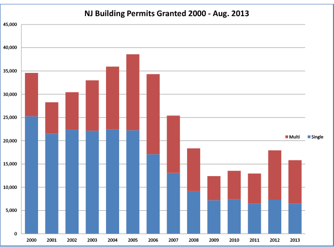
New Construction in New Jersey since 2000 has seen an even trend-line in multi-family housing while single family housing has been on a steady downward trajectory since 2005. Between January 2000 and August 31, 2013 (a one hundred fifty-two month period) there were 351,535 permits granted in the State.  Of these permits, 210,335 (59.8%) were for single family homes and the remaining 141,200 (40.2%) were for multi-family units.

NJ Building Permits 2000 - Aug. 2013

NJ Building Permits 2000 – Aug. 2013

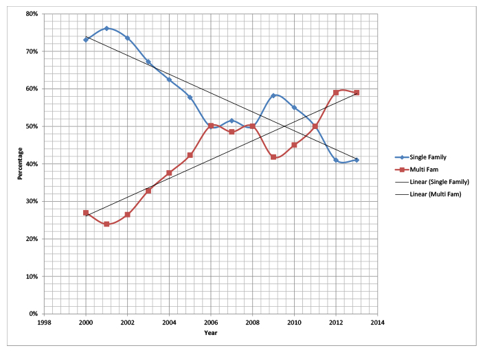
During the study period, single-family permits were at its highest in 2000 when 25,260 single-family permits were granted representing 73% of all residential building permits granted that year.  The number of single-family permits hovered around 22,000 annually for the next five years while the annual number of multi-family permits increased from 6,764 to a peak of 17,210 multi-family permits during that same period.  For the three years (2006 through and including 2008) the number of permits for single family and multi-family were close to even.  Between 2008 and 2009 there was a drop in both permit categories, however the loss was larger in the multi-family class.  2012 saw a 63% increase in multi-family permits, while the single-family permits increased 14% during the same period.

What was a single-family dominated market, has now transitioned to a multi-family market. The following chart shows the relationship between the two permit types as a percent of total annual permits.

Residential Permit Type

Residential Permit Type

Based on the number of apartment, mixed-use and redevelopment proposals legal notices sent out through our Blog, it appears that the development community still believes in multi-family housing.

Let us know your thoughts.

Matt Sprung

Source of Permit Information:   NJ Department of Labor

Tagged

Town of Harrison’s Planning Board to hear Crownpoint Group Application for Apartment Building in Waterfront Redevelopment Plan.

Public Notice:


  PLANNING BOARD  TOWN OF HARRISON PUBLIC HEARING NOTICE CROWNPOINT GROUP, LLC Block 97, Lots 1.04, 23.01, 23.02 & 25  Please take notice that a public hearing will be held by the Planning Board of the Town of Harrison (“Planning Board”) at 7:00 p.m., in the Council Chambers – Second Floor of the Harrison Town Hall, 318 Harrison Avenue, Harrison, New Jersey, on Wednesday, November 13, 2013. The purpose of this hearing is to consider the application of Crownpoint Group, LLC (‘Applicant”) for preliminary and final major site plan approval to enable the construction of one (1) four-story residential apartment building with common facilities and associated improvements on the property. The property is located at the intersection of Bergen and Second Streets and is known as Block 97, Lots 1.04, 23.01, 23.02 & 25 as shown on the official Tax Map of the Town of Harrison, Hudson County. The property is located in the Residential District of the Harrison Waterfront Redevelopment Plan. The project as proposed conforms to the requirements of the Harrison Waterfront Redevelopment Plan and the Municipal Code of Town of Harrison with the exception of the Applicant’s request for design waivers and exceptions for: (i) locating the utility transformer outside at grade; (ii) providing for a sidewalk width of 11.5′ to 12.4′ where 11′ is required; and (iii) allowing the vertical dimension of the opening between columns to be 10′-6″ for the entrance to the clubhouse where 16′-0″ is required. The Applicant also seeks de minimis exceptions from the RSIS allowing (a) 104 parking spaces where 192 are required, and (b) both conventional spaces measuring 8.5″ x 18′ and compact spaces measuring 8′ x 16′, where RSIS requires 9′ x 18’ spaces. The Applicant shall request that the Planning Board grant any additional variances, design waivers or exceptions from the Harrison Waterfront Redevelopment Plan and/or the Municipal Code of the Town of Harrison as determined to be necessary during the review and processing of this application by the Town and the Planning Board. All documents relating to this application may be inspected by the public during regular business hours in the office of the Department of Construction & Engineering located in the Harrison Town Hall, 318 Harrison Avenue, Harrison, New Jersey 07029. Any interested party may appear at said hearing and participate therein in accordance with the rules of the Planning Board of the Town of Harrison. November 2, 2013 Szaferman, Laking, Blumstein & Blader, P.C. Ryan A. Marrone, Esq. Attorney for Applicant 101 Graves Mill Road  Lawrenceville, NJ 08648 609-275-0400 $128.76   

Tagged , , ,

Wenner Bread products seeks to revonate and add to 301,520 sf facility in New Brunswick

Public Notice:


  CITY OF NEW BRUNSWICK
NOTICE OF HEARING CITY OF NEW BRUNSWICK PLANNING BOARD PLEASE TAKE NOTICE that on Tuesday, November 12, 2013, at 7:30 P.M., the City of New Brunswick Planning Board (“Board”), in the City Council Chambers at City Hall, 78 Bayard Street, New Brunswick, New Jersey 08903, will hold a hearing on the application of Wenner Bread Products, Inc. (“Applicant”) for preliminary and final major site plan, bulk variance, and site plan/design exception/waiver approvals (collectively, the “Approvals”) for property located at 571 Jersey Avenue, New Brunswick, New Jersey 08901, and designated on the tax maps of the City of New Brunswick as Block 596.01, Lot 16.05 (“Property”). The Property is located in the I-2 General Industrial District. The Applicant requests the Approvals in order to: renovate the existing approximately 301,520 square-foot warehouse building on the Property for use as a commercial bakery (manufacturing, warehouse and office uses); construct an approximately 25,200 square-foot addition to the building; and make certain site improvements, including parking, landscaping, and accessory grain silos, in connection with same (collectively, the “Project”). The Project will be completed in up to three phases: Phase 1 includes the renovation of the existing building and most of the proposed site improvements, including new curbing, pavement, sidewalks, and striping; the grain silos; landscaping; lighting; and signage. Phase 2 includes the building addition and associated improvements. Phase 3 includes the addition of a rail spur expansion to the rear of the building. In connection with the application, the Applicant requests the following bulk variances from the City of New Brunswick Zoning Ordinance (“Ordinance”): (1) a variance from Ordinance Section 17.04.050 to permit a building coverage of 40.60% where a maximum building coverage of 35% is otherwise required (the Property has an existing building coverage of 37.47%); (2) a variance from Ordinance Section 17.04.050 to permit eight accessory grain silos with a height of 50 feet where a maximum accessory structure height of 15 feet is otherwise required; and (3) a variance from Ordinance Section 17.04.050 to permit a side yard setback of 20 feet where a minimum side yard setback of 25 feet is otherwise required (this condition is pre-existing). The Applicant also requests various site plan/design exceptions with respect to landscaping. While the Applicant believes that the application is otherwise in conformance with the Ordinance, it hereby requests any waivers, variances, deviations, amendments and/or exceptions from the Ordinance as are required to obtain the Approvals. Copies of all documents submitted to date concerning the application are on file at the City of New Brunswick Department of Planning, Community & Economic Development, Civic Square, 25 Kirkpatrick Street, New Brunswick, NJ 08903-0269, and are available for inspection by the public during normal business hours, Monday through Friday, holidays and furlough days excepted. Peter M. Flannery, Esq. Sills Cummis & Gross P.C. 650 College Road East Princeton, NJ 08540 Attorneys for the Applicant Telephone: (609) 227-4600 ($44.72) 891172  

Township of Rockaway seeks Plan Conformance for Planning Area from Highlands Council

Public Notice:


  TOWNSHIP OF ROCKAWAY
LEGAL NOTICE TOWNSHIP OF ROCKAWAY, MORRIS COUNTY ORDINANCE NO. O-13-21 Notice is hereby given that an Ordinance entitled “Ordinance to Petition the Highlands Council for Plan Conformance for the Planning Area” was submitted in writing at a regular meeting of the Mayor and Council of the Township of Rockaway, County of Morris, State of New Jersey, held on October 29, 2013 and was introduced, read by title and passed on first reading. A Statement of Purpose of the Ordinance is contained below. The governing body of the Township of Rockaway will further consider the ordinance for second reading and final passage thereof at their regular meeting to be held November 26, 2013 at 7:30 p.m. prevailing time, at the Municipal Building in said Township, at which time and place a public hearing will be held thereon by the governing body and all parties in interest and citizens shall have an opportunity to be heard concerning said ordinance. STATEMENT OF PURPOSE OF ORDINANCE   The Township of Rockaway is located partially within that portion of the New Jersey Highlands Region defined by the Highlands Act, as the “Planning Area” (see definitions, below). This Ordinance is enacted pursuant to Section 15.a. of the Highlands Water Protection and Planning Act (Highlands Act, N.J.S.A. 13:20-1 et seq.), which provides that a municipality may choose to conform its master plan, development regulations, and other regulations to the provisions of the Highlands Regional Master Plan, with respect to lands located within the Planning Area, and by Ordinance, petition the New Jersey Highlands Water Protection and Planning Council (Highlands Council) for Plan Conformance approval of such planning and regulatory documents. By adoption of this Ordinance, the Governing Body of the Township of Rockaway establishes that the municipality shall conform its master plan, development regulations, and all other regulations applicable to the use and development of land within the Planning Area of the municipality, to achieve consistency with the goals, requirements, and provisions of the Highlands Regional Master Plan. Said conformance shall be in accordance with the provisions of Highlands Council approval of the municipality’s Petition for Plan Conformance, which was previously submitted to the Highlands Council by Resolution adopted by the Governing Body on November 4, 2009, and which the Highlands Council approved with certain conditions by Highlands Council Resolution No. 2011-10, adopted on February 17, 2011. Further, this Ordinance specifically reserves the rights of the municipality as specified by the Highlands Act, with respect to the voluntary nature of Plan Conformance for the Planning Area. A copy of the full Ordinance is available for review by any member of the general public without cost, at the Township of Rockaway Municipal Building, 65 Mount Hope Road, Rockaway, New Jersey, at the Office of the Township Clerk, between the hours of 9:00 a.m. and 4:30 p.m. Susan Best, Township Clerk Township of Rockaway County of Morris, State of New Jersey ($45.76) 891349  

Tagged ,

NJ Highlands cancels meeting of the Highlands Development Credit Bank scheduled for Nov. 7th

STATE OF NEW JERSEY
NOTICE OF MEETING CANCELLATION NEW JERSEY HIGHLANDS DEVELOPMENT CREDIT BANK Please take notice that the meeting of the Highlands Development Credit Bank scheduled for Thursday, November 7, 2013 at 4:00pm has been cancelled. ($5.20) 889224


Public Notice ID: 20744160.HTM
Tagged

City of Clifton awards contract to consider status as Receiving Area for Highlands TDR Program

NJ Highlands Council TDR  Feasibility Study Awarded

CITY OF CLIFTON NOTICE FOR CONTRACT AWARD   The City of Clifton has awarded a professional services contract without competitive bidding as a professional service pursuant to N.J.S.A. 40:11-5(1)(a). This contract and the resolution authorizing it are available for public inspection in the Office of the City Clerk.  Awarded to: Jill A. Hartmann, PP, AICP,  Mahwah, NJ Services: Professional Planning Services Project: NJ Highlands Council TDR  Feasibility Study Amount: $140 hr/not to exceed $15,000 Term: Until Completion Nancy Ferrigno City Clerk  Herald News-3555917 Fee: $10.11 September 6, 2013

Tagged ,

Sayreville Approves Major Subdivision and Site Plan for the Crossman Industrial Development, LLC.

Public Notice:

  BOROUGH OF SAYREVILLE
Take Notice that on Wednesday, October 16, 2013 at the Meeting of the Planning Board of the Borough of Sayreville, NJ the following was memorialized by Resolution. Crossman Industrial Development LLC Block 251, Lot 1 Main Street, Sayreville Major Subdivision and Site Plan The Resolution of the Planning Board covering same is filed in the Office of the Secretary of the Planning Board and the Office of the Borough Clerk and are available for inspection Monday through Friday, from 9AM to 5PM. Patricia Gargiulo, Secretary Sayreville Planning Board
Editors Note:  This is a 55 acre parcel per Tax Assessment data.
Tagged ,

Woodbury Heights adds Affordable Housing Zone

Public Notice:


>  PUBLIC NOTICE    ORDINANCE 15 – 2013    ORDINANCE AMENDING THE ZONING ORDINANCE AND ZONING MAP FOR THE BOROUGH OF WOODBURY HEIGHTS, GLOUCESTER COUNTY, NEW JERSEY    WHEREAS, by the Borough Council of the Borough of Woodbury Heights, County of Gloucester and State of New Jersey (“the Borough”) has proposed a revised Housing Element and Fair Share Plan Amendment to the Master Plan; and    WHEREAS, the Borough Council has deemed it in the best interest of the public health, safety and welfare to implement the aforesaid Amendment to the Master Plan: and    WHEREAS, in order to facilitate the consistency of the Woodbury Heights Master Plan with the Land Use Code and Ordinances of the Borough of Woodbury Heights, the Borough Council desires to codify and implement the recommendations contained in the aforesaid Housing Element and Fair Share Plan Amendment; and    WHEREAS, to further implement the Amended Housing Element and Fair Share Plan, the Borough intends to hereby establish a new Zoning District entitled “Residential Multifamily Affordable District (RM-2)” and to further supplement and amend the Zoning Ordinance as follows:    A. Create a new Section 70-13.3 under Article IV, District Regulations as follows:    1.  Section 70-13.3 Residential Multifamily Affordable (RM-2)    A. The purpose of the RM-2 District is to provide for the construction   of supportive housing for persons of low and moderate income   consistent with New Jersey’s Fair Housing Act, N.J.S.A. 52:27D-301   et seq., the rules of the New Jersey Council on Affordable Housing   and the Mount Laurel Doctrine.    B. Permitted Principal Uses.    1.   All principal permitted uses in the Residential – R district  under Section 70-13A.    2.  Supportive Housing in single-family, semi-detached or   quadruplex dwelling units.    C.   Accessory Uses Permitted.  All accessory uses permitted in the R   District under Section 70-13B.    D.   A maximum density of 13 units per acre.    E.   Maximum Building Height in accordance with Section 70-13C.    F. Area and Yard Requirements.    1.    For all uses as permitted in the R-District the area and   yard requirements of Section 70-13D, apply.    2.  Supportive Housing Single-family units in accordance with   the following:            Minimum Lot Area:              5,000 square feet          Minimum Lot Width:      50 feet          Minimum Lot Depth:    100 feet          Minimum Side Yard Setback: 10 feet          Minimum Front Yard Setback:  25 feet          Minimum Rear Yard Setback:  25 feet    3. Supportive Housing Semi-Detached single-family units in  accordance with the following:            Minimum Lot Area:                        3,750 square feet          Minimum Lot Width:                        37 feet          Minimum Lot Depth:                        100 feet          Minimum Side Yard Setback:         0-feet and 10-feet          Minimum Front Yard Setback:        25 feet          Minimum Rear Yard Setback:        25 feet    4.  Supportive Housing Quadruplex Swelling Units in   accordance with the following:    Minimum Lot Area:                  10,000 square feet  Minimum Lot Width at Building Line:  100 feet  Minimum Lot Depth:        150 feet  Minimum Side Yard Setback: 15-feet with an   aggregated of 25-feet  Minimum Front Yard Setback:        30 feet  Minimum Rear Yard Setback:        30 feet            G.   Design Criteria.    1.   If parking is proposed in the front yard for the duplex units,   the front yard setback shall be increased to accommodate  all spaces on-site.    2.  Parking for the quadruplex units shall be provided in the   rear yard area.  The total number of spaces shall meet the   Residential Site Improvement Standards.  All parking areas  shall be screened from adjoining properties.    3.  Street/Shade trees shall be provided for each residential   unit with a minimum spacing of one tree for every 50-feet   of lot width.    4.  Landscaping plans shall be provided including foundation   plantings.  Perimeter plantings/fencing shall be provided   adjacent to existing single-family dwelling units.    BE IT FURTHER ORDAINED, that the Zoning Map for the Borough of Woodbury Heights is hereby amended to designate that land and premises known as Block 91, Lot 6 of the Official Tax Maps as within the Residential Multifamily Affordable (RM-2) District, thereby repealing its former District Designation;    BE IT FURTHER ORDAINED, as follows:    1.  Repealer.  Any and all other Ordinances or parts of Ordinances inconsistent with the terms of this Ordinance are hereby repealed to the extent of any such inconsistency.      2.  Saved from Repeal.   Any and all other Ordinances or parts of Ordinances not inconsistent with the terms and provisions of this Ordinance are hereby saved from repeal.            3.  Filing.  Upon adoption, a copy of this Ordinance shall be forthwit